Deal or no deal, streaming live sports takes some maneuvering just to keep up. Now that NFL season has started, you may be thinking of YouTube TV’s NFL Sunday Ticket as an option to stream football. It’s not cheap, though. Whether you pay for it in installments, get it as a perk through Verizon or have a student discount, you’re still shelling out money. But for NFL fans, there’s a way to watch Sunday Ticket without spending money on a subscription. The catch? You’ll have to leave the house.
DirecTV has an app called Sports Bar Finder that helps you locate bars and restaurants around the US that offer 15 TV sports packages, including NFL Sunday Ticket. It’s available via web browser and operates using your location or by inputting a postal code.
If you’re unsure about paying $276 for a new Sunday Ticket plan or up to $480 as a returning customer looking to resurrect your subscription for the 2025 season, then this could be an alternative. I tried out Sports Bar Finder (and called a few establishments to confirm they’ll carry the package this season) and have provided a walkthrough on how it works.
How to use Sports Bar Finder for NFL Sunday Ticket
The Sports Bar Finder app used to be available for Android and iOS devices, but it’s now only accessible via a web browser.
Navigate to Sports Bar Finder, where you’ll be prompted to type in a bar name, share your location or enter a postal ZIP code.
The list will populate with area restaurants and bars, giving you the option to filter the results by sports package. Select NFL Sunday Ticket from the list. You can also skip this step and just look for the Sunday Ticket badge under each establishment’s information.
You can choose from the main list of bars shown in the results or click Featured to see the app’s highlighted locations.
Click on View Additional Bar Details. Each bar and restaurant provides the address, hours and available sports TV packages at that location. However, whether you’re in your own neighborhood or visiting another city from out of town, we suggest you call ahead to verify that games will be broadcast.
Tapping the heart icon will save a location to your Favorites section, so you can easily track some of your favorite places to watch Sunday Ticket or other sports offerings such as Big Ten, Friday Night Baseball or Thursday Night Football.
To tailor the results even more, you can filter by amenities (e.g., Wi-Fi or good for groups) or rating. The app pulls ratings from Yelp reviews.
Want more NFL and sports-related coverage? Check out CNET’s pieces on streaming services like Fox One, game-day watch information and NBA news.
The feeling of bringing your ideas to life? Unmatched. Imagine creating your own jewelry sets, custom accessories, home decor pieces or even phone cases. 3D printing makes all of that doable, and right now, it don’t cost an arm and a leg.
Currently, the Bambu Lab A1 combo — which includes our favorite printer, the A1, and AMS Lite filament syste for multi-color printing — is down to $575 on Amazon. That’s 33% off a solid setup but the discount might not be around for long.
The A1 printer offers impressive speed with 10,000 mm/s² acceleration while maintaining excellent accuracy. Full-auto calibration automatically handles bed-leveling, Z-offsets, and more — no need for continuous monitoring or manual adjustments. Pair this with AMS Lite, and you won’t be stuck printing in just one color (no fun in that). It lets you load up to four colors and paint your model digitally.
Our 3D printing expert, James Bricknell, reviewed the Bambu Lab A1 Combo and was quite impressed with both its print quality and ease of use. He highlighted the easy setup process and appreciated the ability to monitor prints through the Bambu Handy app — naming it the best 3D printer available right now.
The Bambu Lab A1 also earned CNET’s Editors’ Choice Award 2024, scoring a 9.2/10, which says a lot in a market full of options. Note that while the A1 printer and AMS Lite can be purchased separately, going that route will cost more compared to this already discounted combo.
3D printing is fun, but it can be expensive, especially if you’re looking for a machine that’s easy to use, fast and doesn’t compromise on accuracy. This deal lets you save $280 on an excellent pair that combines fast printing with several smart features. Just note that the deal is a limited-time one, so be sure to grab it quickly.
I’ve written hundreds of articles about broadband internet technology, but I’d never heard about data being transmitted through invisible lasers before. This wasn’t the plot of a sci-fi movie. This was Taara, a graduate of X, Google’s Moonshot Factory, that uses beams of light to transmit data through the air at the speed of light.
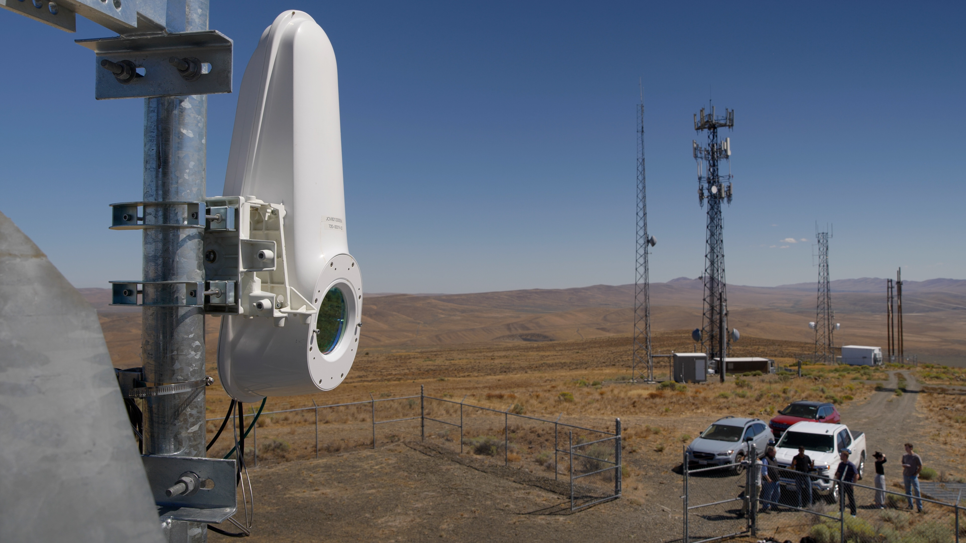
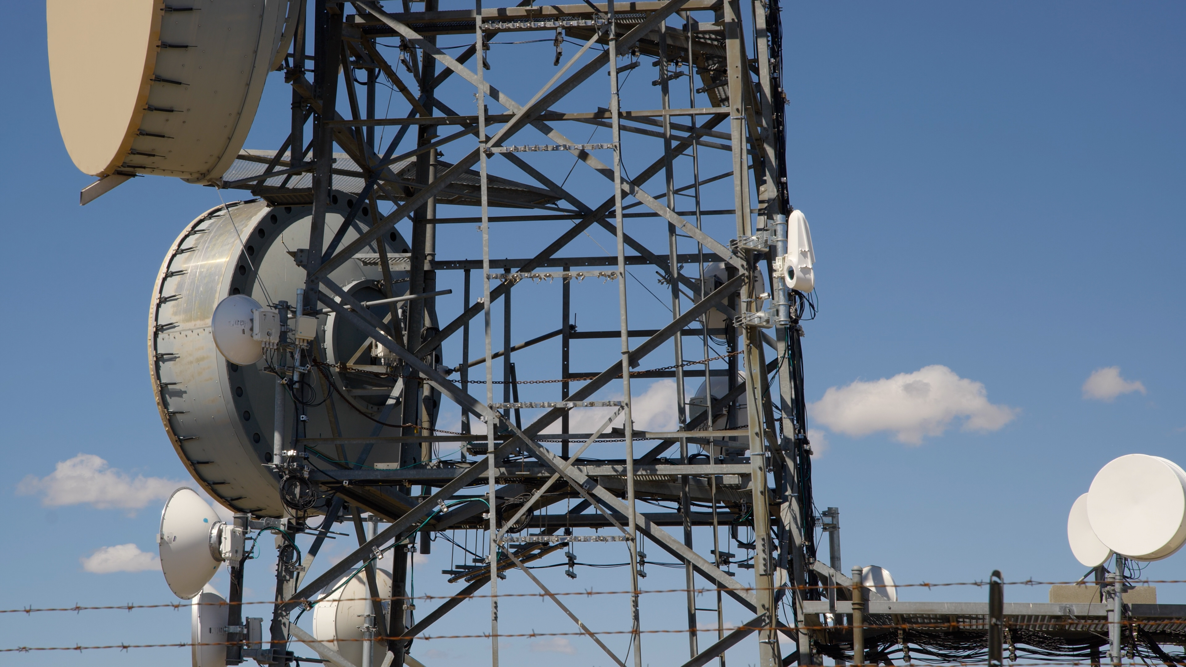
I drove 140 miles from my home in Seattle to remote Selah, Washington, to see it in action. Three miles up a rocky dirt road, you’ll find a typical cellular tower, dotted with antennas dating back 40 years.
If you know what you’re looking at, you can read it like a climate scientist reads ice cores. The oldest antennas on the tower could only send 44.74 Megabits of data each second, or about 14% of what the average American home gets today. The biggest could send 1.4Gbps up to 50 miles away. I imagined the giant snare drums beaming birthday texts, Netflix shows and video meetings all over the Yakima valley.
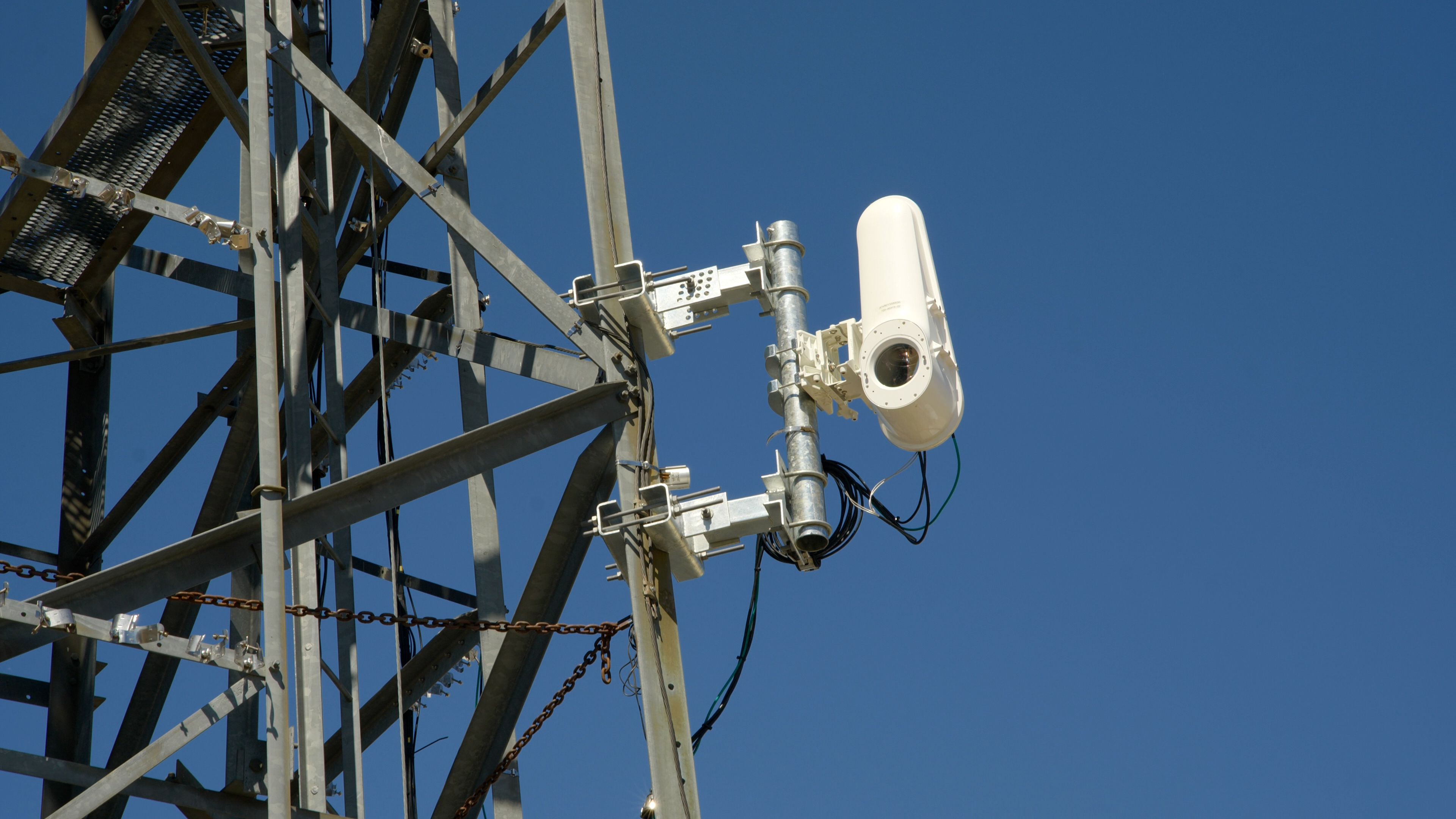
Seeing these aluminum mammoths up close was so overwhelming that I almost missed what I came up here to see: a white box the size of a traffic light tucked into an open corner of the tower.
Taara’s Lightbridge terminal sits on an open corner of the cell tower owned by StarTouch.
Jesse Orrall / CNET
The biggest antennas on the tower were capable of sending 1.4 gigabits per second total; Taara can do 20Gbps in both directions, up and downstream, at distances up to 12.4 miles. The first would allow 56 TVs to stream in 4K at the same time. Taara said its terminal could do 800 — and that was just in the downstream lane.
“The world has moved past the capabilities of that,” said Taara founder and CEO Mahesh Krishnaswamy, gesturing toward the largest antennas on the tower. “Fiber is future-proof, but you can’t get it everywhere, like here. That’s why we’re so excited. It’s a sea shift in the way we think about communications.”
Fiber optic internet has been widely considered the gold standard in data transmission for decades, but it can be incredibly difficult to build — especially in mountainous terrain like Selah. The thin strands of glass that carry data are buried several feet underground, and providers have to navigate a complex permitting process to get them there. Taara bypasses all of that by removing the “fiber” part of the equation and sending it directly through the air.
Broadband infrastructure expansion is more nuts and bolts than glitz and glamour. Innovations tend to occur around the edges. Cellphone companies advanced from 4G to 5G, pushing into new areas of the electromagnetic spectrum when older frequencies got crowded. Satellite internet had even been around for decades before Starlink. Starlink just pulled them down closer to Earth to improve its latency and speeds.
Taara
Taara operates in the 190 terahertz range, between visible light and infrared.
“That’s exactly the same frequency that is inside a fiber optic cable,” Krishnaswamy says. “What we have done is essentially removed the sheeting of the cable and transmitted that same data wirelessly. So effectively, Taara can offer the speeds of fiber, but do it in a wireless way without having to dig or trench or lay fiber.”
Don’t miss any of our unbiased tech content and lab-based reviews. Add CNET as a preferred Google source.
How Taara plans to cross America’s ‘middle mile’
Taara’s technology falls under the umbrella of free-space optical communication, which refers to the wireless transmission of data through light. You could argue that the idea has been around since ancient times, when light or smoke signals were used to communicate across distances, but the modern version of FSO came with the availability of lasers in the 1970s and 1980s.
“Taara is not alone in the present market, and FSO companies have come and gone since the early 2000s,” said telecom industry analyst Dan Grossman.
Companies like Attochron, Transcelestial and X-Lumin also use lasers for data transmission, but none of them are as proven as Taara, said Scott Bernard, the director of engineering for StarTouch, a Washington-based company that has been trying out Taara on its cell tower in Selah for the past few months.
“We did talk to other folks. I just didn’t feel like they were quite far enough along,” Bernard told me, citing Taara’s deployments in India and Africa as proofs of concept.
Bernard said StarTouch works with two of the “Big Three” cellular carriers to expand connectivity in hard-to-reach areas.
“We’re definitely out in the hinterlands of Washington state,” he said. “We’re pushing to the bounds of the network. We’re at the very edge. Fiber hasn’t made it out here yet. And it may not, because it doesn’t make financial sense.”
Selah is just a few miles north of Yakima, a city with a population of nearly 100,000. Data from the Federal Communications Commission shows that 31% of Yakima residents have access to fiber, compared with 6% in Selah.
Jesse Orrall / CNET
As I stood next to the cell tower on the Selah mountaintop, I was struck by what a massive undertaking it would be to lay fiber across this rugged terrain.
“It took us 30 minutes to even drive up here. There are no roads. There is no easy way to access this,” Krishnaswamy said. “You’d have to dig and trench and lay fiber in all of these places. And it’s cumbersome. It’s expensive.”
That’s the problem Taara is aiming to solve. It costs $10 to $27 per foot to bury fiber underground, or $52,800 to $142,560 per mile, according to a 2024 survey of firms that build fiber networks. (Installing it on poles is slightly cheaper, but less common.) It’s likely on the higher end in rocky, mountainous terrain like Selah.
“If it’s going to cost you $100 a foot to bore through a rocky ledge, this is a pretty attractive option,” Grossman told me.
Instead of going underground, Taara connects the fiber network in Yakima to the cell tower in Selah entirely through the air.
“All you need is one terminal to be able to see the other terminal, and you’re able to transmit the full 20 gigabits per second without any issues,” Krishnaswamy said.
A 2021 report from the International Telecommunication Union found that 58% of the world’s population lives within 15.5 miles of a fiber network, but 32% are still left offline. The reasons for that are complicated — most people without home internet in the US say affordability is a bigger barrier than access — but none of those factors exist in a vacuum. Infrastructure investments allow more providers to operate in an area, which in turn lowers prices for customers.
In Selah, you could see the fiber network off in the distance with the naked eye, but those world-class speeds would have been inaccessible without Taara. That patch between the fiber infrastructure and the cell tower is what’s known as the “middle mile.”
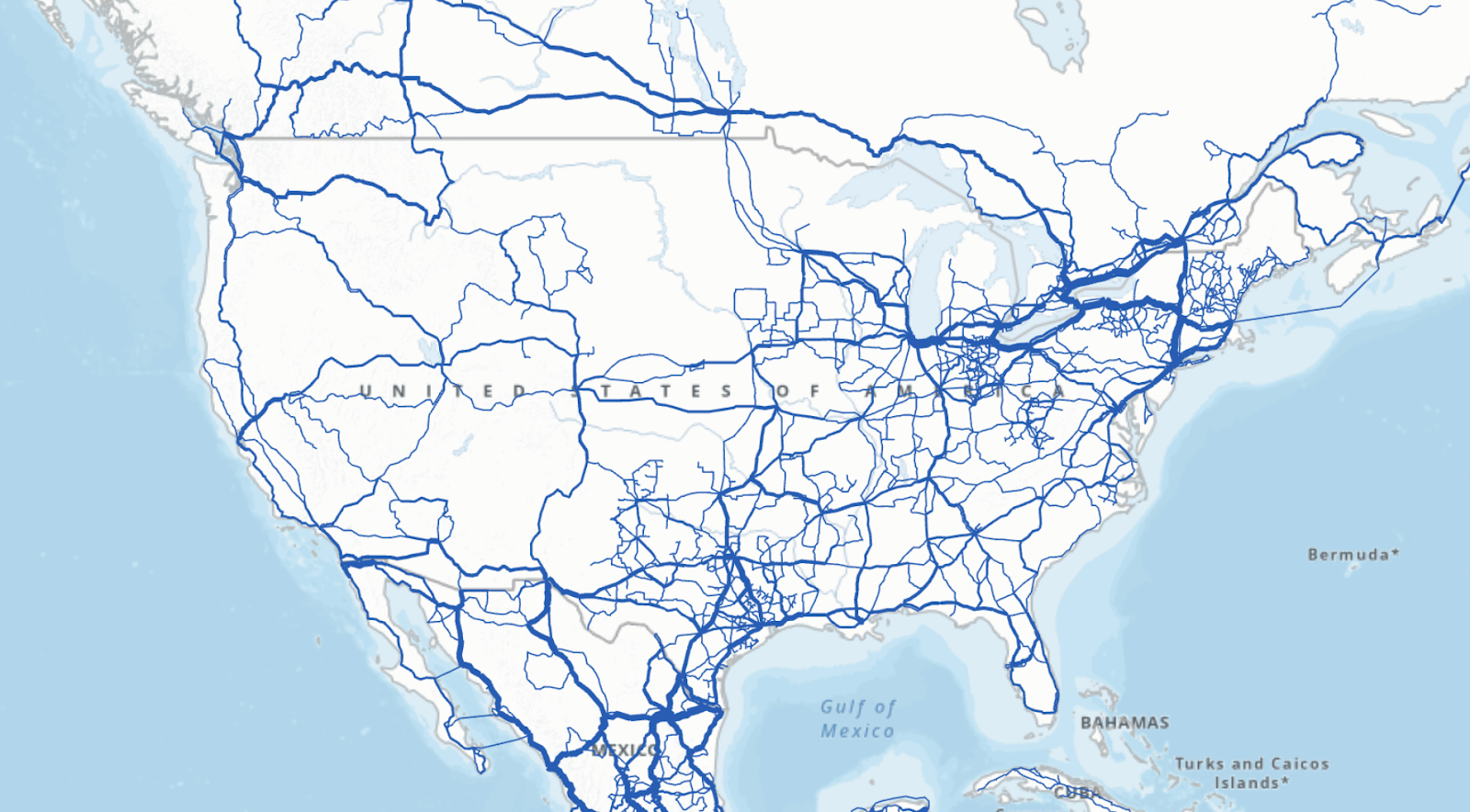
The US has more than 186,000 miles of fiber optic networks.
The International Telecommunication Union (ITU)
According to the ITU, 94% of the country lives within 31 miles of a fiber network. But traversing those miles is often more expensive and time-intensive than internet providers are willing to invest. Taara’s pitch is that it can cross a dozen miles in the few hours it takes to install.
“Fiber could take a long time in places like out here in the middle of nowhere,” Bernard explained. “The fiber POP [point of presence] could be 30 miles away.
“With Taara, you can get your customers on the network fairly quickly. The permitting process and getting on the towers — it’s months, not years.”
The National Telecommunications and Information Administration, an agency under the Commerce Department, is currently doling out $42.5 billion to states under the Broadband Equity Access and Deployment Program. The goal is to expand infrastructure for high-speed internet in rural areas — particularly to addresses that don’t have a single home internet provider available. Taara’s Krishnaswamy recently outlined in a blog post how Taara could help internet providers cross the middle mile with BEAD projects.
“Historically, every country has advanced by actually finding some way to subsidize or augment the connectivity infrastructure project,” Krishnaswamy told me. “What we are trying to do is work with partners and ISPs and fiber operators who are delivering this and provide resiliency to the network.”
Jesse Orrall / CNET
Birds, fog and monkeys
One obvious question jumped out to me as I looked at the Taara terminal in Selah: what happens if something like a bird gets in the way of the laser? Would my Zoom meeting drop out?
“Birds are a big problem,” Grossman said. “A bird flying through one of those beams for a quarter of a second is going to kill a lot of bits.”
When it comes to things like live streaming, that would likely cause a glitch in the video.
“You will see a brief interruption, or it may seem like a brief interruption,” Krishnaswamy said, explaining that software inside the terminal detects the interference. “We have a repeat request, which is a retransmission of the data, so the other side doesn’t even notice that brief blip of loss of packets.”
Jesse Orrall / CNET
The cell towers that house many Taara terminals can also be vulnerable to disruption. Early on, even small vibrations or gusts of wind would knock the laser off its course. When Taara was installed in India, the local animal population even presented an engineering hurdle.
“Monkeys were all over the tower shaking it,” Krishnaswamy told me. He says the experience led them to develop new stabilization technology inside the terminal.
“Even if the tower sways, we know exactly how much it’s swaying and compensate in the other direction so it stays locked,” he said.
But the company’s biggest bogeyman has actually been fog, which scatters light at the same wavelength that Taara operates in. In those cases, Taara uses radio frequencies as a backup. Selah isn’t prone to fog, but it occasionally gets heavy rainfall that could disrupt the light beams.
“What we’ve seen is it’d have to be a pretty significant storm. But that’s why you have an underlay,” Bernard said, referring to the radio frequency backup. “We at least have a way to keep the lights on.”
What does the future look like for Taara?
Krishnaswamy was understandably hyped about the path ahead for Taara. He described a utopian vision of the future for connectivity around the world: endless bandwidth for all.
“There’s really no upper limit,” he said. “There is so much spectrum available in the light domain. If you were to compare it to the radio frequency, you could fit the entire radio frequency spectrum inside the light domain, and you wouldn’t even scratch the surface.”
Each Taara laser is about the size of a chopstick, so there’s nothing stopping Taara from adding more if the 20Gbps isn’t enough. Krishnaswamy said his team has gotten the number as high as 160Gbps by stacking the lasers.
“That’s complete overkill to these kinds of places considering that you only are using 5% utilization right now,” he said.
He referred to an oft-cited rule in the broadband world called Nielsen’s law, which states that a high-end internet user’s connection speed grows by roughly 50% each year, doubling every 21 months. This has held true every year since 1983. To keep up with that pace, most experts agree that fiber optic needs to be the backbone of any future network. Can Taara really do the same thing through the air?
Bernard, the director of engineering at StarTouch, told me he “absolutely” plans on adding more Taara terminals in Washington.
“We’ve been very happy, and we are looking to deploy more,” he said. “This is a very good tool in the toolbox.”
Everything about laser internet sounded exciting, but the tech world is full of lofty promises. Taara was even born out of one — another Google Moonshot project called Loon that used balloons in the stratosphere to deliver internet. Light beams were used to help the balloons send high-speed data to each other. Loon’s dreams were deflated and Taara’s rose from the ashes.
As Grossman, the telecom industry analyst, said, “There is a difference between marketing claims and what actually works in the field. Taara has a lot of systems in the field, so I think it more likely than not that it works, but how much they’ve stretched that is another question.”
So far, Taara is living up the hype in Selah. Will it be the game-changing solution that Krishnaswamy envisions? Is there really no “upper limit” on the amount of bandwidth Taara could supply on the light spectrum?
Only time will tell, but I know I’ll be looking at every cell tower I see with fresh eyes, trying to spot a white traffic light with the laser eye nestled among the behemoths.
The invite, which Apple sent on Aug. 26, shows the title “awe dropping,” with a dynamic Apple logo that seems to reference Siri’s colorful glow.
There’s also an interactive element when you view the invite on Apple.com. With a finger (phone or tablet) or a mouse/trackpad pointer (computer), you can move across the logo and watch the colors go from a cool blue to a vivid orange, possibly evoking the Liquid Glass design element in iOS 26, which exhibits light-bending qualities across apps and functions. You can read more theories about what the fall event invite might signify.
The keynote will be held at Apple Park in Cupertino, California. CNET will be covering the announcements live, so be sure to follow along.
Technically, Apple has yet to confirm the iPhone 17, but the company typically unveils its latest handsets at its fall event.
Rumors for the upcoming slate of iPhones have been plentiful. Stealing the spotlight is the supposed iPhone 17 Air, which could follow in the footsteps of Samsung’s sleek Galaxy S25 Edge and have a slim profile and lightweight design. The Pro model could get a scratch-resistant, antireflective display and an 8x telephoto lens, and the Pro Max could pack a bigger battery. The baseline iPhone 17 could also boast a higher refresh rate. It’s possible that all the phones may include an Apple-developed 5G modem called the C1 chip, which debuted on the iPhone 16E, as well as in-house Wi-Fi chips.
We also expect to learn more about the public rollout of iOS 26 later this fall. The new operating system features a Liquid Glass interface that brings a more transparent, lens-like look to the iPhone and other Apple devices. The Camera app also gets a more minimalistic design, Messages lets you create polls in group chats and a new screening tool can better detect spam texts. You can check out all the features coming to iOS 26.
What we might not hear as much about is the updated version of Siri that Apple unveiled at its Worldwide Developers Conference last year. The smarter version of the AI assistant has faced repeated delays and may not arrive until next year. But Apple could discuss other Apple Intelligence updates and features arriving on its new devices.
CNET’s reporters will be on the ground, bringing you all the latest updates and impressions of whatever Apple has in store. You can watch our livestream here starting at 9:30 a.m. PT/12:30 p.m. ET:
You can enjoy hiking in many ways, from strolling along flat trails to trekking through the woods to tackling challenging terrain in mountainous landscapes. Regardless of the approach, hiking has countless health benefits, such as improving cardiovascular health, boosting mood and enhancing cognitive functioning, and fostering a connection with nature.
You’ll find a number of hiking apps available — so many, in fact, that it can be difficult to narrow down your options. I’m an avid hiker, and AllTrails has been my primary resource for the past decade, but I’ve been testing seven other top-rated hiking apps for the past month to find those worth downloading. From the top app for curated trails to my favorite for building custom routes, here are the best hiking apps for your next outdoor adventure.
Disclaimer: You should never solely rely on a phone app while hiking or exploring remote areas. Read on to learn why with expert safety tips from a professional mountain guide.
Best hiking apps of 2025
Disclaimer and warning: Don’t rely solely on an app
Apps aren’t always accurate
Never rely solely on an app for navigating the outdoors. For one, there’s no perfect hiking app. Given our ever-evolving environments, trail closures, changes in property ownership, climate change and so on, these apps are bound to have outdated, inaccurate or missing information. They also don’t always function perfectly — I’ve encountered occasional glitches on every hiking app I’ve tested.
Through personal experience, I’ve learned it’s often best to use two apps (and offline maps) when trekking in challenging or unfamiliar terrain, especially when there’s no cell reception. You can cross-reference and compare the apps when making directional decisions along your route.
Here’s an example of how hiking apps aren’t always reliable. This particular trail underwent some construction and rerouting last year. I was able to navigate it just fine without relying on an app, but all three indicated that I had gone off-route because their databases hadn’t been updated to reflect this changed section.
They’re useless if your phone dies
Consider bringing a physical map, compass, personal locator beacon (PLB) or satellite communicator. That way, if something happens to your phone — whether you lose it or your battery dies — you aren’t completely SOL.
Anouk Erni of Blackbird Mountain Guides, AMGA-certified rock and ski guide and IFMGA aspirant mountain guide, explains, “I highly recommend having a satellite device. While some devices like a PLB have just an emergency locator feature, other devices allow for two-way texting and map use. A popular satellite device is the Garmin InReach Mini, which allows communication via satellite either directly through the device or by Bluetooth pairing it to a phone. You can two-way text through a Garmin app on the phone, get weather updates, check one’s location on the app’s map and call for help by pressing an SOS button. There are other devices out there, such as the Zoleo and Garmin Messenger.”
If there’s an emergency and you need to communicate with rescue services in an area with no cell signal, remember that you may be able to use your phone (if it’s in working condition). The iPhone 14 and later models offer Emergency SOS via satellite, allowing you to contact emergency services when you don’t have reception. I had to use this feature on a hike recently, and I was able to communicate with emergency personnel successfully. T-Mobile also offers a Starlink-based satellite service for $10 per month, allowing you to send and receive text messages without cellular coverage.
Though it’s a great feature, keep in mind it may not always work perfectly. “Many folks are starting to use the SOS messaging feature on the iPhone; however, that feature has not been perfected in the backcountry yet and is not guaranteed to work all the time. In addition, relying on just one electronic device (e.g., your phone) is not recommended for emergency contact because of possible battery depletion or phone malfunction,” says Erni.
Factors to consider when choosing a hiking app
Selecting the right hiking app for you will require trial and error, and your priorities will likely shift over time. The good news is that most hiking apps offer free versions and free trial periods. I recommend downloading and trying a few to see which best fits your preferences and lifestyle. Remember that there’s always a bit of a learning curve — especially with apps with this many features and functionalities — so don’t give up if it feels confusing or frustrating at first.
Consider the following characteristics when choosing the right hiking app for you:
Functionality: Do you want the ability to create custom routes on detailed topographical maps of backcountry terrain? Or are you looking for a comprehensive list of curated trails, complete with user reviews and photos? Will you use the app for skiing, hunting, fishing or fieldwork activities? Are you looking for community-based trail guides for specific thru-hikes? Determining what you want and need from the app first will help narrow your options.
Map features: If you plan and execute hiking trips off the beaten path, consider which map features and overlays you need. Do you need public and private land boundaries? Satellite imagery? US Forest Service maps? Do you need overlays such as slope angles, sun exposure, wildfire activity or cell reception?
Offline navigation: The offline navigation capability is arguably the most essential aspect of your hiking app. If you can’t access your maps or GPS navigation in areas with no cell service, they won’t be of much use.
Price: Most hiking apps have multiple tiers of plan options, and many require an upgrade to download and navigate maps offline. Consider your budget and whether you’re willing to pay for a subscription. Subscription pricing varies among apps, which can help narrow down your options.
Hiking app honorable mentions
National Park Service
The National Park Service app is free and offers information on more than 400 US national parks. It features interactive maps with points of interest, roads, trails and attractions. The app also helps you locate amenities such as transportation, food and restrooms. The NPS app even has neat self-guided tours you can listen to while traveling through the park, complete with markers to learn more about the park’s history, geography, wildlife and more. I highly recommend that the next time you visit a National Park, you use this app for park news, road closures, alerts, event information, and so on.
You can download content and maps to access offline, a nice feature that not many hiking apps offer for free, but it’s not the most robust navigational tool. I’d still recommend having another hiking app with the trail maps downloaded to use as you trek in remote areas of the park.
Topo Maps Plus
Topo Maps Plus is another great option for people who need to access detailed topographic maps offline. It’s suitable for hiking, backpacking and fishing and for wilderness guides and field professionals such as reclamation specialists who monitor land restoration after mining, agriculture or construction disturbances.
Tay Lopez, a reclamation specialist, relied on Topo Maps Plus during his four years of field work, marking off old mine locations and pinning the coordinates of new mines on the app.
“The app offers a ton of maps and customizability. It works well on Apple products like iPhones and iPads; you can even navigate the maps on an Apple Watch. Exporting coordinates and downloading the maps for areas without cell reception was very easy. I would recommend this app for people who are not going on typical hikes, per se, but more for those who need to plan and mark routes in the wilderness or navigate complex terrain,” said Lopez.
Avenza Maps
Avenza Maps is a popular app for hikers, bikers, skiers and hunters who need reliable offline maps and accurate navigation. Like CalTopo, it’s also popular among search and rescue teams, first responders, foresters, geologists and other field professionals. It features professionally created maps (rather than crowdsourced) from publishers like National Geographic and government agencies that constantly update their maps. You can also import your own georeferenced PDF maps.
Strava
Though Strava isn’t designed as a hiking or navigational app (it’s known as an app for runners and cyclists), it includes route-tracking and records metrics like distance, time and elevation gain. You can share your hikes with friends and family and interact with the activities of others on the app. The app also has popular hiking routes, but it requires a subscription. It also features a global heatmap to help you see which trails are most popular.
How we tested the best hiking apps
Although I’m not a professional mountain guide or extreme hiker, I’ve been hiking regularly for more than a decade and would consider myself advanced. I hike multiple times a week and have summited a handful of challenging peaks, including Mount Whitney, Half Dome and Costa Rica’s Cerro Chirripó, as well as many other notable hikes around the Sierra Nevada mountains where I live. I enjoy hiking in national and state parks across the US and exploring trails while traveling internationally.
AllTrails has been my primary source for locating and navigating hikes until recently. I’ve exhausted most of the known trails around our area and sought a new app to help me plan and execute more backcountry hikes.
I’ve tested seven other hiking apps for the past month to compare and contrast features and functionality. The main qualities I considered when selecting the apps on this list include functionality and features, user interface, trail database, offline maps, navigation, pricing and reviews.
User interface: I’ve familiarized myself with each app’s interface, learning its features and functionalities. I note whether it’s pretty intuitive and easy to pick up or if there’s a significant learning curve. Once I have a trail picked or a custom route created, I’ve been hitting the trails and using the apps to navigate, paying attention to how accurately the GPS tracks my movements, how easy it is to follow the trail and how the maps display on my phone.
On each hike, I use two apps to compare and contrast their functions. I note whether they have glitches or issues with rotating the screen and zooming in or out, as well as which maps are most accurate compared with the actual paths, landmarks and general topography in front of me.
Offline navigation: One of the most critical components I looked at is access to maps and navigation offline. After all, it doesn’t matter what app you use if it won’t work when you lose cell service. Luckily, these offline features are becoming industry standard, and most outdoor hiking apps now offer them — though they’ll make you pay for it. I always download the trail and maps I need before heading out (I’ve been burned by not doing that in the past).
Features: I examine the app’s other features, including extra overlays, weather forecasts, satellite previews, safety tools and community features, such as whether there are user-generated reviews and photos. Finally, I look at the posthike interface and assess how accurately the app measured all my metrics during the hike.
I asked the experts
Anouk Erni of Blackbird Mountain Guides, a highly experienced, certified mountain guide with an impressive list of credentials longer than the alphabet, offered expert insight.
“Many guides and recreationalists use either CalTopo or Gaia for planning routes and downloading maps with different topographical layers. These apps work very well for trip planning and allow you to incorporate layers such as snow coverage, global imagery, US Forest Service maps and topo and contour lines. If you’re into creating routes on your map, these have many features, such as creating geospatial PDF topo maps that you can download onto your phone for offline use. I like to have these PDFs downloaded to my phone, as well as use the app to access the route and orient myself in the moment. The apps sync all your information quickly — but make sure to download the maps for offline use before going out of service, so that you can use them to orient yourself throughout the hike. Other decent options for apps are AllTrails, Avenza and onX,” explains Erni.
It’s an ongoing process
Testing hiking apps is an ongoing process. Hiking application companies constantly evolve and upgrade their products, improving the technology and offering more features, trails and functionalities as their database grows. This roundup of the best hiking apps will evolve as we continue to test them, so check back at CNET for updates.
Phone battery tips
Using a hiking app on your phone (or two at a time, like I’ve been doing) will inevitably drain your phone battery. I’ve been taking a few extra steps to ensure my phone doesn’t completely die while I’m exploring remote places.
Phone settings
If you don’t have cell service, consider putting your phone in airplane mode to prevent it from constantly searching for a signal.
When you’re not using it to navigate or look at the maps, put it on power saving or low-power mode to reduce brightness, limit apps running in the background and optimize overall performance.
You’ll probably also want to turn off background app refresh and disable location services for most apps except those needing GPS tracking while hiking.
Be sure to download your maps ahead of time to access them offline so that you aren’t using data to search and interact with your maps.
Bring a portable charger
Be sure to fully charge your phone before heading out on a hike. I also bring a portable charger on longer day hikes or overnight backpacking trips. I like the Anker MagGo power bank because it’s pretty lightweight, sticks firmly to my phone and provides plenty of juice.
I’ve said it before, and I’ll say it again — bring a physical map and compass as backup. Our phones aren’t always reliable, and it’s best to be prepared for whatever the trail may bring.
“Know how to read a map and use a compass. It is not uncommon for hikers to veer off trail where it may not be well marked, if there is snow coverage or if hiking in the dark. Being able to acknowledge the error and get back to the trail quickly can be the deciding factor between a successful adventure or a rescue mission. These days, technology has provided mapping apps that are easy to use and follow, so practice using these apps and maybe watch some tutorials,” Erni emphasizes.
A “good” trail depends on what you’re looking for. If you’re seeking a curated trail, I recommend starting with the free version of AllTrails, because you can search in the area you want to hike and narrow down your options with the handy filters feature. You can sort based on the distance and elevation you want to trek, and on whether the trail is dog-friendly, kid-friendly, or has attractions like lakes, waterfalls or scenic views. Be sure to read the reviews left by other hikers for extra insight and tips on what to expect.
What features do I need in a hiking app?
It depends on the type of hiking you’re doing. If you’re hiking on a popular, well-trodden path within cell reception, you may not need an app with downloaded maps for offline use. However, suppose you’re venturing into unfamiliar territory or expect you won’t have cell service. In that case, you’ll want to prioritize a hiking app that allows offline map access so you can still navigate.
Additionally, to ensure you’re on the right path and record your route, look for a hiking app with GPS tracking capabilities (most have them these days). If you plan a long day hike or backpacking in the wilderness, you may need more-complex features, such as localized weather conditions, slope angle overlays, public and private land boundaries, and more.
What should you bring on a hike?
Say you’re going on a single-day hike, there are a few items I recommend having with you (the gear you’ll need for an overnight hike or backpacking trip will be quite a bit more extensive). Bring multiple layers of lightweight and protective clothing, because you never know what type of inclement weather you may encounter. Bring plenty of water and a filtered water bottle (my favorite is the Grayl Geopress) or LifeStraw to fill up and rehydrate whenever you cross water sources such as lakes or rivers. Be sure you have enough snacks, calories and electrolytes to keep you fueled and hydrated. Wear protective gear such as a hat, sunglasses and sunscreen.
If you’re heading into bear territory, I recommend bear spray or a safety alarm if you come across any creatures on the trail who aren’t in a particularly friendly mood. Finally, bring a compass, physical map and a transponder or satellite communicator — phones certainly aren’t foolproof or indestructible.
Some T-Mobile customers during the past week have been surprised to discover a new — and enabled by default — feature in the T-Life app called “Screen recording tool.” In light of recent iffy recording tools such as Microsoft’s Recall AI feature in Windows, seeing a feature that records the contents of your screen is bound to raise privacy concerns.
If you’re a T-Mobile subscriber, you can check if this new option has been turned on by opening the T-Life app, tapping Manage and then tapping Settings (the gear icon). The Screen recording tool option shows up under the Preferences heading.
If the option is there, tap it to reveal a description and a toggle switch. The description reads: “We use a tool to record how customers use the app to analyze and improve your experience. Only T-Mobile will review and analyze your info. If you turn this toggle on or magenta, we will record your screen while you use the app. If you turn this toggle off or gray, we will not record your screen.”
To disable the feature, tap the switch so it becomes gray. (The “magenta” and “gray” in the text refer to the color of the toggle switch to indicate whether it’s active or not, respectively.)
When I reached out to the company for more information, a T-Mobile spokesperson defended the feature, saying it was designed to improve the user experience.
“To help us give customers who use T-Life a smoother experience, we are rolling out a new tool in the app that will help us quickly troubleshoot reported or detected issues,” the spokesperson said. “This tool records activities within the app only and does not see or access any personal information. If a customer’s T-Life app currently supports the new functionality, it can be turned off in the settings under preferences.”
According to a post on droidlife, which earlier referenced the issue, the new option shows up on both iPhone and Android phones.
On the face of it, the Screen recording tool appears to do what it says, and the fact that it’s limited to just the T-Life app is a reasonable, and expected, limitation.
But as with all potential privacy issues, the fact that T-Mobile is enabling the feature by default has rightly made customers suspicious. It should be off initially, and if an issue arises that would require screen recording, then the company could get permission from the phone owner to turn it on.
T-Mobile in fact has a similar setup within the T-Life app. There’s another screen recording feature that is completely separate from this new Screen recording tool. In the app’s settings, under Help & support, is Screen Share, which can be used during a support call. It allows a T-Mobile expert to view your phone’s screen while troubleshooting an issue. It requires several steps and requires you to consent to having your screen recorded before allowing a support expert to connect to the app.
If you’ve ever tried to help a friend or family member over the phone and asked them to describe what’s on the screen, you’ll appreciate how helpful it can be to view what they’re seeing directly.
Whether you’re rocking the latest Apple Watch Series 9 or a previous model, watch bands don’t come much cooler than the Apple Leather Link. It’s versatile enough to use for any occasion and the soft leather adds a luxurious touch of class to any outfit. It’s also among Apple’s most expensive bands at $99 which make it pricier than most other options.
Woot’s summer deals are here to help and right now you can grab a Leather Link in different size and length configurations for just $25, a savings of $75. This watch band is currently available in ink (navy). Just be sure to do it soon, this sale will end in seven days or until supplies last. Some configurations are already sold out.
Apple doesn’t only make one of the best smartwatches around, but it’s also responsible for some of the best bands, too. In the case of the Leather Link, the construction is the key thanks to the use of Venezian leather that’s handcrafted in Arzignano, Italy.
If that isn’t enough, the concealed magnets that allow for a firm yet highly customizable fit should be enough to get you interested, while the super-thin design means you won’t have to walk around with a massive chunk of leather stuck to your wrist. The band is available for 38mm, 40mm and 41mm Apple Watches. The band is available only in size medium-large, to fit wrists 165mm to 180mm in circumference, which might rule out those with more petite wrists.
Don’t worry if you don’t yet have an Apple Watch to go with your new band, because we’ve got you covered. Our list of the best Apple Watch deals will have something for everyone, and now you can save cash on your fancy new band as well.
Christmas will be here in just a few days, so there’s not much time left to buy gifts for your friends and family. Even though we’re certain that you have all the gifts you need, there is always a chance that you might unexpectedly need to buy more gifts for someone you didn’t plan for, especially if you’re showing up to a holiday party.
If you need some help, this Target tip is here to stop you from scrambling and so you don’t show up empty-handed.
Take a look at our shopping tip on three ways you can capitalize on Target’s last-minute shopping options; plus deals you can grab too.
Even if it’s too late for shipping, what you can do is use order pickup. Order pickup is such an easy way to get something online, by having you search, place your order and then pick it up in-store without the hassle of crowds.
On Target’s order pickup page, everything is already broken down by gift types, making it easier for you to search. Here are a few categories:
You can place online orders when you’re using order pickup all the way up until 6 p.m. local time on Christmas Eve.
If you prefer never leaving your car, you can use the Drive Up service. In order to use Drive Up, you have to use the Target app, which you can download on Android and Apple devices. Here’s how Drive Up works:
You also have by 6 p.m. local time on Christmas Eve to pick up your online orders when you’re using Drive Up.
Using Shipt is a little different than the other two options. If you plan on going this route, you have till 4 p.m. local time for same-day delivery. That said, using Shipt is very easy. Here are four ways you can place an order using same day delivery:
Want to save more right now, and in 2023? Here are additional Shopping Tips to help you do just that.
The deep darkness of space might not actually be so dark in our solar system.
Astronomers analyzed over 200,000 images from NASA’s Hubble Space Telescope, making tens of thousands of measurements to try to locate a residual background glow in the night sky. The project is called Skysurf, and it’s based at Arizona State University and involves researchers there and around the world.
The team harvested data from the images and then subtracted the glow from planets, stars, galaxies and even ethereal zodiacal light, which is light reflecting off dust within our solar system.
After accounting for all this, there was still a tiny bit of leftover glow or “ghost light,” which the researchers describe as equivalent to the glow of 10 fireflies spread across the entire night sky.
“We think it is a local phenomenon that is not from far outside the solar system,” ASU researcher Tim Carleton explained in a statement Thursday. “It may be a new element to the contents of the solar system that has been hypothesized but not quantitatively measured until now.”
A leading explanation is that the glow comes from a previously unaccounted for sphere of dust left behind by countless comets traveling through the solar system from all directions.
One of the studies was led by Rogier Windhorst from ASU, who points out that over 95 percent of the photons in Hubble’s images come from distances on our side of the universe, less than 3 billion light-years from Earth.
“Since Hubble’s very early days, most Hubble users have discarded these sky-photons, as they are interested in the faint discrete objects in Hubble’s images, such as stars and galaxies,” Windhorst said. “But these sky-photons contain important information which can be extracted thanks to Hubble’s unique ability to measure faint brightness levels to high precision over its three decades of lifetime.”
And within that information, Windhorst and others may have just located a completely new piece of ethereal architecture underlying our entire solar system. If you consider a faint but ubiquitous layer of dust to be architecture, that is.
If you don’t want to sign up for a Costco membership right now, Instacart is a great way to still shop there.
Angela Lang/CNET
Tons of people love Costco, but there are also a bunch of people who don’t understand the appeal of the warehouse club and don’t feel as though shopping there would benefit them. There’s not a whole lot of in between, and it’s reflected in the fact that you either pay for an annual membership or decide to not shop there at all. Wouldn’t it be cool if you could still shop there occasionally without needing to enroll in a membership? It’s possible, but there are some things to know about the process.
Odds are you’ve heard of or even used Instacart to have something delivered to you at some point. But did you know that you could order from Costco via Instacart and have it delivered without needing a membership? Costco does have some items that are specifically member-only, but shopping through the Instacart app opens you up to a whole new variety of products, and best of all you can do it from anywhere.
Getting started with this is super easy, but let’s break down the process for you.
1. Download the Instacart app or go to Instacart.com from your browser.
2. Create an account or sign in to your existing account.
3. Navigate to the Costco Storefront in Instacart.
4. Load up your cart with items that you wish to purchase.
5. Select your delivery time and checkout.
That’s it. Really. It’s just that easy to buy from Costco and have it delivered to you, all without ever needing to pay for an annual membership. As previously noted, there are a few things worth knowing about this, so let’s break them down.
Shelf-stable items including cereal, sauces and coffee represent some of the biggest savings when buying in bulk.
VIEW press/Getty Images
You’ll spend a little more for the convenience
The prices that are charged through Instacart are often more expensive than the prices you’d see if you were to go into a Costco location and do your shopping there. That’s because you need a membership to shop in person and because Instacart is providing the service of picking and delivering your order.
None of the items or pages indicate directly how much more expensive it is to use Instacart than to shop at Costco in person, which is a good and bad thing at the same time. The convenience factor makes it worth paying a little extra for the items in most cases.
In some cases, Instacart could have coupon savings that will make items more affordable as well. These are clearly marked on Instacart, so be sure to look out for items that indicate coupon savings when purchasing.
The order process takes place through Instacart
This is one of the most confusing parts. Costco.com has an experience that offers same-day delivery for members that’s powered by Instacart (which is called Costco Same-Day) and Instacart offers same-day delivery from Costco for non-members. See how that can be confusing? If you don’t have a Costco membership right now, you will want to make sure you are doing your ordering via the Instacart app or site, and not exploring directly from Costco’s own site.
Keep in mind that Instacart does add a delivery fee for every same-day order, which starts at $4. All orders must be $10 or more and deliveries under $35 are charged more. Costco also charges for its same-day orders and has a strict $35 order minimum.
Not everything is included with this trick
While a lot of what Costco sells is available both online and in its warehouse locations, not everything is sold in both places. You won’t be able to place orders through Instacart for items that are online only. In addition, Costco does have some items that are exclusively available to its warehouse members, so you won’t be able to buy those. Some examples of that include the Bose Quiet Comfort 45 headphones, Nest Hub two-pack, a Samsung 55-inch TV with extended warranty and much more.
For some, it may be cheaper to just get the membership
Using this trick is great if you only need something from Costco once in a while. It’s a great way to test the water with Costco, to see if you like the products and if it could provide value in the end for you and your family. Online, and in the warehouse, Costco showcases the price per item or per weight which allows you to easily compare what you’re buying to the competition.
As you are looking around and ordering, make note of where the better prices are and see how long it would take you to get your money back if you paid the annual membership. The results for your situation may surprise you. Some of my personal Costco favorites are Kirkland toilet paper, paper towels, Just Bare chicken nuggets, pulled pork and of course the Liquid I.V. packs.